Location or position ?
This is a very short graphic novel that shows how we think about positioning and locating networked equipment.
We consider a network to be a topology that consists of connected linear elements. Equipment has a function, a position on the surface of the earth and a location in the network. The latter is distinct from "classic" GIS thinking where objects have a position on the surface of the earth expressed in coordinates.
Short, position and location both inform whereabouts:
- position where on the surface of the earth
- location where in the network
Equipment that operates in a network topology, be it railways, telecoms or utilities, is attached to linear elements, e.g. pipes, wires, or rails. More often than not the map position is less relevant than the location in the network. This said, depending on their roles, people may be interested in either map position or network location. A network designer may only need to know about routes whereas a maintenance engineer needs to know how to drive to a piece of kit by car.
Spotemkim
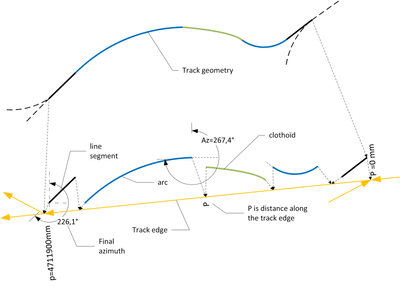
Location with respect to a curvilinear feature such as a railway track often is more interesting than a position in euclidean space or on a map.
This diagram shows that location is given with respect to a "curvi-linear element of the network" which typically is the centre-line of a track (or pipe, road, cable, etc.). The spot is then said to be located at an "intrinsic coordinate" which is the relative distance along the feature in the range [0,1]. This allows ordering kit on the linear feature even if the absolute distance along the feature is unknown. Note that the linear element can have a length that is expressed in metres or whichever unit is appropriate. This supports the idea that lengths, positions and locations can result from observations of the real world. These observations can have meta-data informing quality, source, date of observation and much more. To the casual user, the meta-data may not be of interest. The façade design pattern is the elegant solution because it states that a thing has a spot location that hides complexity.
The position on a map, sheet of paper or the surface of the earth is optionally informed.
Against this backdrop, the railway model thinking can be stated like so
Function:
- A signal is a lamp on a stick
- A signal has a set of aspects
- A signal aspect sends instructions to the train
Topology for network location
-
A signal is located next to a linear element
-
A linear element is a piece of track that runs from point to point (or buffer stop)
-
A linear element is an element of the topology
-
A linear element links to another element (along which a train can travel)
-
A relation is positioned at the end of two elements Linear elements are "glued" together, head-to-head, tail-to-tail or head-to-tail.
-
A Signal is located at a given Spot
-
A spot location can be attached to a linear element
-
A spot location is located at a given distance-along a track
Topography for map position
- A spot can have geographic coordinates and/or
- A spot can have a position on a display or sheet of paper
RailSystemModel by UIC
All this and much more informaton about this elegant approach is found on the website of RailSystemModel (RSM) created by the Union Internationale des Chemins de fer (UIC) here and in more detail
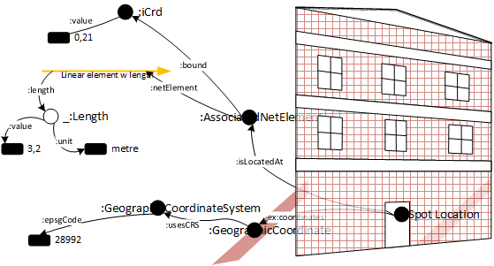
Spot located kit
Track assets have a location. Below figure shows object types with punctual position, i.e. spot locations. A SpotLocation is a façade for
- geo-coordinates and/or
- cartesian coordinates on screen or sheet of paper and/or
- track-related location
The track-related location is expressed as an association to a linear element plus the (relative) distance travelled along this linear element.
Track assets located on tracks, known as net elements.
Distance is awkward
Below list shows locations of signals with intrinsic coordinate. The intrinsic coordinate is the relative distance travelled along the track. To get a distance in metres, one needs to multiply with the length of track. The length of track may be unknown, inaccurate or there may even be several measures, pending a measurement campaign.
To get rid of this awkward dependence on absolute length, the intrinsic coord was introduced. It informs the order of things that a train would encounter when travelling down a track, something that network traversal algorithms need. Often, there's no need for the actual distance along track.
Signal positions along track
Locating linear things
Other things, such as platforms or speed profiles, have a linear location. Other things, such as control areas or train vacancy detection can have an area location.
A linear location is a projection on one or more linear elements. For instance, a speed segment on linear element X runs from distance 0,23 to 0,47. This includes a sense of direction. Things get a touch more tricky when a linear element straddles more than one linear element but only slightly.
An area location is said to be spanned by a set of spot locations where the spot locations are a contour of the area. This is close to a linestring. Alternatively, an area can be seen as a set of linear locations which is convenient when one prefers to think of an area as a a subset of the network without caring about the position on a map.